This interim status report outlines achievements, early findings and outstanding tasks for our cross-organizational glossary pilot project.
Pilot Overview
Glossaries are easy to set up for simple examples but extremely hard to scale - especially when a project wants to inherit terms from other organizations. This pilot has been set up to test cross-domain management of glossaries. We started in August 2020, and plan to have tested pilot goals by March 2021.
We are testing glossary software, standards, and processes, and applying them to cross-organizational use cases within the geospatial mapping domain.
For more details, refer to our manifesto.
Pilot contributors: Cameron Shorter, Alyssa Rock, Ankita Tripathi, Naini Khajanchi, Ronald Tse, Reese Plews, Rob Atkinson, Nikos Lambrinos, Erik Stubkjær, Brandon Whitehead, Ilie Codrina Maria, Vaclav Petras
Current status
Our interim status as the start of December 2020 is as follows:
| Task
|
% Complete
|
| Define glossary goals
|
90%
|
| Establish implementation Plan
|
80%
|
| Establish a healthy community
|
70%
|
| Implement/adopt software platform
|
70%
|
| Establish schemas for terms
|
70%
|
| Define sentence structure for terms
|
70%
|
| Connect external glossaries
|
10%
|
| Collate and clean Open Source Geospatial (OSGeo) terminology
|
60%
|
| Document template governance processes
|
10%
|
Goals
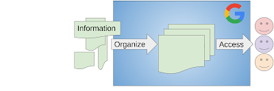
Task: Define glossary goals.
Understanding the problem is the first step needed to then address it.
Figure: Connected glossaries, source
Status:
Implementation plan
Task: Establish implementation Plan
Status:
-
Within the Glossary Pilot Manifesto we articulated steps for standing up a cross-organizational glossary pilot. We have been steadily working against this plan.
Community
Task: Establish a healthy community:
Apache, one of the leading open source foundations prioritizes “community over code”. A strong community will solve any technical challenges faced.
Status:
-
We have attracted a motivated, competent, and cross-functional team of 5 to 10 people (depending on how you count), who are steadily working through our backlog of tasks. Collectively we have decades of experience with glossaries, tech writing, standards, software, and the geospatial domain we are initially focusing on.
-
We have a weekly status meeting, sometimes complemented by additional meetings, along with a slack channel, and email list.
Outstanding:
-
We have only attracted one of the many OSGeo open source projects to sign up as a pilot. This is likely because we haven’t made the signup process easy enough yet, and our tools and processes need improving.
-
After completing the pilot and releasing an alpha version, we’d want to scale our community into other domains (beyond our current spatial domain focus).
Glossarist platform
Task: Implement/adopt software platform
Status:
-
We’ve adopted the glossarist open source software to manage terminology. This provides terminology management of terms, and publishing of terms via a standards based web service.
-
Ribrose, who develop this software, has been working with us to update the software to address use cases and feedback we are finding during testing.
-
Extra functionality is expected to be included during the remainder of this pilot.
Schema
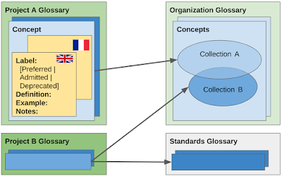
Task: Establish schemas for terms
Figure: Glossary schema, sourcing from upstream glossaries, source
Status:
Sentence structure
Task: Define sentence structure for terms.
Status:
Connect glossaries
Task: Connect external glossaries
Status:
-
In theory, we are very close to connecting two glossaries. In practice, we still need to set this up, which is a focus for the rest of this pilot.
Governance
Task: Document template governance processes
Figure: Glossary governance, source
Status:
While we have been discussing and making use of our own unwritten governance process, we are yet to write this down and provide it as template guidance.
Spatial use case
Task: Collate and clean Open Source Geospatial (OSGeo) terminology
Status:
-
We’ve collated OSGeo terminology from around ten OSGeo glossaries along with OGC and ISO terms.
-
These terms have been aligned with writing rules.
-
We’ve just started looking at terms from the GRASS project, and plan to integrate these too.