The results of the first few years of colloboration under the Emergency Information Coordination Unit (EICU) were presented at a workshop, Friday, 15 May 2009. While the data is still in the pilot phase, it was impressive to see how many of the datasets from different agencies lined up, and interesting to see how easy it was to identify glitches in z-axis points when displayed in 3D for the first time.
EICU call for Data Standards
A few participants and presenters recommended that standards be defined for sharing data between agencies. This sparked my interest as there are a number of OGC initiatives that we Australians have a lot of experience with which are directly applicable to the EICU.
The Canadian Geospatial Data Infrastructure Interoperability Pilot
 The Canadians, under their Geoconnections program, addressed the same EICU use case of sharing data between agencies by providing data from multiple provinces through a single portal interface as if it were coming from one database. The data was updated at source and made available in real time. This was acheieve during the Canadian Geospatial Data Infrsatructure Interoperability Pilot, run as an OGC testbed, by using cascading Web Feature Services. The pilot also provided a workflow for users to feed updates back to data custodians, and search and discovery provided through a catalog interface. LISAsoft in Australia developed a Geoserver based cascading Web Feature Service and the browser based client.
A video of the pilot can be viewed at: http://www.youtube.com/watch?v=YIZLc_qHYZc .
Community Schemas
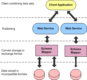 As explained in more detail in this article, Community Schemas describe specific attributes and data structures for a data community. The community schemas act as a wrapper over disparent datasets, facilitating sharing between agencies.
Australia, and CSIRO in particular, pioneered much of the work related to Community Schemas in the development of GeoSciML and WaterML. LISAsoft supported the project by developing community schema performance and validation tools.
CityGML
CityGML is a specific Community Schema which offers the key building blocks for a EICU schema. CityGML was the basis for much of the latest OGC testbed, OWS6, which LISAsoft provided validation tools for. The results of this testbed are planned to be presented in as a webinar early in June 2009. Let me know if you wish to be informed when the webinar is announced. An good overview of CityGML is provided in the OWS RFQ:
CityGML is an open data model and XML-based format for the storage and exchange of virtual 3D city models. It is an application schema for the Geography Markup Language version 3.1.1 (GML3), the extendible international standard for spatial data exchange issued by the Open Geospatial Consortium (OGC) and the ISO TC211.Tapping into OGC test beds
The aim of the development of CityGML is to reach a common definition of the basic entities, attributes, and relations of a 3D city model. This is especially important with respect to the cost-effective sustainable maintenance of 3D city models, allowing the reuse of the same data in different application fields.
CityGML not only represents the graphical appearance of city models but specifically addresses the representation of the semantic and thematic properties, taxonomies and aggregations. CityGML includes a geometry model and a thematic model. The geometry model allows for the consistent and homogeneous definition of geometrical and topological properties of spatial objects within 3D city models. The base class of all objects is CityObject which is a subclass of the GML class Feature. All objects inherit the properties from CityObject.
The thematic model of CityGML employs the geometry model for different thematic fields like Digital Terrain Models, sites (i.e. buildings; future extensions of CityGML will also include explicit models for bridges and tunnels), vegetation (solitary objects and also areal and volumetric biotopes), water bodies, transportation facilities, and city furniture. Further objects, which are not explicitly modeled yet, can be represented using the concept of generic objects and attributes. In addition, extensions to the CityGML data model applying to specific application fields can be realized using the Application Domain Extensions (ADE). Spatial objects of equal shape which appear many times at different positions like e.g. trees, can also be modeled as prototypes and used multiple times in the city model. A grouping concept allows the combination of single 3D objects, e.g. buildings to a building complex. Objects which are not geometrically modeled by closed solids can be virtually sealed in order to compute their volume (e.g. pedestrian underpasses, tunnels, or airplane hangars). They can be closed using ClosureSurfaces. The concept of the TerrainIntersectionCurve is introduced to integrate 3D objects with the Digital Terrain Model at their correct positions in order to prevent e.g. buildings from floating over or sinking into the terrain.
CityGML differentiates five consecutive Levels of Detail (LOD), where objects become more detailed with increasing LOD regarding both their geometry and thematic differentiation. CityGML files can - but do not have to - contain multiple representations (and geometries) for each object in different LOD simultaneously. Generalization relations allow the explicit representation of aggregated objects over different scales.
In addition to spatial properties, CityGML features can be assigned appearances. Appearances are not limited to visual data but represent arbitrary observable properties of the feature’s surface such as infrared radiation, noise pollution, or earthquake-induced structural stress.
Furthermore, objects can have external references to corresponding objects in external datasets. Enumerative object attributes are restricted to external code lists and values defined in external, re-definable dictionaries.
Future EICU initiatives, focusing on cross agency collaboration, provides an excellent opportunity to engage OGC participation. OGC participation provides access to international expertise and ensures R&D work flows into future standards and products. Australia is in an excellent position to lead an OGC initiative. Though the EICU, we have the business drivers, multiple agency support and local expertise. It would make a nice change to work on a testbed where meeting times align with Australian timezones.
1 comment:
Colloboration needs good utility records.
Whether part of a utility circulation process, co-build design process, construction or operation process, you must be ready to produce utility “records” as evidence that an event, set of activities, or task occurred and was completed. The record, field note, sketch, or plan needs to contain relevant, factual, and timely data in a form that is understandable to those who must make the decision. The goal is to create a good record, that is accessible, retrieveable, has a know distribution list, and those accessing are able to share it, manipulate it and use it to make decisions with.
In Canada we are creating a CSA standard - "s250 - Mapping of Underground Utility infrastructure" involving utility companies, municipalities, contractors, excavators, locators, regulators and other parties interested in protecting and min damage to underground utilities.
This CSA committee is responsible for developing and maintaining standards related to mapping and recording of existing in-service underground utility infrastructure and related appurtenances below, at, or near grade and those that are either abandoned or that are reserved for future use.
This new standard will specify the mapping requirements of records that provide the identification and location of underground utility infrastructure
This standard is intended to promote the use, and drive the advancement of mapping records, during the planning, design, construction, and operation of an underground utility.
Key Challenges:
-Need to remind ourselves of the benefits of having a standard
-Need to maintain interest in the standard by committee members and all stakeholders
-Need to assess how the standard will be embraced and then sustained
Expected outcomes:
--Improved reliability and accuracy in the location of underground utility infrastructure mapping records & supporting data
--Improved safety of company & contractor employees and the general public by decreasing utility hits/strikes
--Lower cost in the utility design life cycle by sharing accurate & complete utility records in a timely fashion amongst all users (municipalities, carriers, contractors, designers, consultants, locators…)
For more information - contact
Bob Gaspirc, Chair, CSA s250 at
gaspirc@toronto.ca
Why:
-Good records lead to informed decisions
-Codification of best practises
-Provides a technically neutral language
-Creates a consistent and repeatable approach to mapping and recording of facility information
“as per CSA S250”
-Promotes communication among utility infrastructure stakeholders and reduces infrastructure life-cycle challenges
Post a Comment