Showing posts with label foss4g. Show all posts

Monday, 5 August 2019

Considering future Open Geospatial conferences in Oceania

“What should we do about upcoming conferences for Free and Open Source Software for Geospatial (FOSS4G) and State of the Map (SotM) within our Oceania region?”


Image by @mapmakerdavid
We didn’t have an answer to this question at the last OSGeo Oceania board meeting. At the moment, no one is volunteering to chair. No one is backing a city with commitment, and that is a problem we hope to solve.

Pertinent is that the international FOSS4G will be held somewhere outside of Europe or North America in 2021 and a call for a two-page Expressions Of Interest is coming out in September 2019 (soon). We have a very compelling case for bringing the international community to our region, if we try.

Are you keen to see FOSS4G and SotM continue in our region? Do you have ideas about where and how? Would you like to help make it happen? Are you interested in mentoring or being mentored by a bunch of committed volunteers who have worked on prior FOSS4G events? If so, why don’t you talk to us? Come join our email list and introduce yourself. We particularly want to hear ideas about what we should do about FOSS4G in the next two years.

Some history:
  • 2009: FOSS4G-International in Sydney. During the global financial crisis, we had lower attendance than expected, but managed to stay profitable when similar conferences were losing money.
  • 2018: FOSS4G SotM Oceania in Melbourne. Exceeded expectations for size, sponsorship, activities, and engagement.
  • 2019: FOSS4G SotM Oceania Wellington: Has already exceeded sponsorship targets and sold out early bird tickets within a week.
  • 2020: FOSS4G SotM Oceania: Where?
  • 2021: FOSS4G-International: Should we bid for it?


Friday, 7 September 2018

Child friendly conferences

We have introduced a Child Friendly policy at the FOSS4G-Oceania conference as part of our "diversity" focus. We are quite proud of it, and think we have reached an effective balance between the competing priorities of:

  • High cost of dedicated childcare.
  • Variability and unpredictability of different aged children.
  • Retaining a professional conference environment.
  • Respecting needs of children, parents, and conference participants.
  • Making our conference accessible to a diverse audience, which includes those responsible for children.
Hopefully other conferences will draw inspiration from our work embrace something similar. This is what we have come up with:

Child Friendly Conference

A child-friendly FOSS4G SotM event

FOSS4G SotM Oceania is aiming to be a child-friendly conference. This means we encourage parents to bring their children (still young enough to require minding) to the event, and for those children to be able to integrate with the community.

How does this work?

The conference Code of Conduct describes expected behaviour for everyone at the conference: https://foss4g-oceania.org/conference/code-conduct

Here are some additional principles for considering children.

As parents, we all know that it is impossible to expect our children to sit quietly for any length of time unless they are engaged with whatever is going on. As such, we request that parents:

  • Be prepared to move in and out of sessions as required by their children.
  • Occupy seats near exits in sessions.
  • Self-organise with other parents to manage children if there is a must see session or talk.
  • Be aware of the needs of other conference attendees, who have also paid to turn up and hear people speak.
  • Extend the principles of the conference Code of Conduct to children, both yours and others. Treat them respectfully, and avoid corporal punishment.
In kind, we request that everyone:
  • Be patient with children. They are our future leaders and learn by modelling what we do.
  • Be patient with parents. Children are not robots and don’t have ‘quiet now’ buttons.
  • Leave seats near exits free, for use by parents and children (see above - they may need to make quick exits)
  • Assist. If you see a child looking lost or distressed, get down to their level and ask them how you can help. Find a conference volunteer to hand over to.
Remember parents are doing the best they can. At the conference, if you have issues with children or parents, please contact the diversity team (as per the Code of Conduct).

If you feel that your child will not disrupt your presentation, you are welcome to bring them on stage (if they want to). Please organise this with your child ahead of time, so that you can arrange a carer or some other way of occupying your child while you speak.

For parents wanting tools to assist with helping their children get through a conference, there is a wealth of material that may be useful here: https://www.handinhandparenting.org/blog/.

What does it cost to bring children?

Children can attend for free. The catering cost is covered by the Good Mojo program. Please let us know as soon as you can if you are bringing your child(ren) so we can adjust numbers appropriately.

We all know that children can eat in amazing disproportion to their physical size, and we will cater for them as adults.

What facilities are available for parents?

The conference will aim to provide a ‘chill space’ - a refuge for parents and children at the venue. The University of Melbourne has fantastic outdoor spaces (please use them!); but Melbourne weather is not always friendly.

We are also looking into a specific space for breast pumping/feeding - however, breastfeeding mums are welcome to feed wherever they feel comfortable doing so (with respect also to the needs of your child).

While we will do our best to provide spaces away from the buzz, this is at present a work in progress - look out for updates!

Please use the foss4g-oceania-discuss e-mail list or join us on the Maptime Australia Slack to discuss with the FOSS4G organisers and coordinate with other conference parents. (Many of the organisers are also parents)


--//--

Special kudos goes to Adam Steer who has been the primary driver behind getting this initiative off the ground.


Thursday, 30 June 2016

OSGeo-Live 10.0 beta1 released. Test sprint / Doc update


OSGeo-Live 10.0 beta1 is ready for download at [1]. We're looking for testing applications and updating docs and translations.

In particular, we need help to:
  1. Check if any new features need to be added to Project Overviews
  2. Run Quickstarts and verify they work as described. Please join us on irc://freenode.net#osgeolive this weekend, 2 & 3 July 2016, for our testing sprint.
  3. Update review status in our spreadsheet [2]. (It really helps us know if an application has been reviewed, and by who).
  4. Translate docs that have been updated.
  5. OSGeo-Live is scheduled to be the default installation at FOSS4G 2016 workshops. We strongly urge all workshop leaders to test OSGeo-Live now and provide feedback, while there is still time to tweak anything required for the workshop.

What's Changed:

New applications:
  • PyWPS 3.2.5
The following applications have been updated:
  • 52nWPS 3.3.1 -> 3.4.0
  • 52nSOS 4.3.0 -> 4.3.6
  • GpsPrune 17.2 ->18.3
  • GeoMoose 2.8.0 -> 2.9.0
  • GRASS 7.0.3 -> 7.0.4
  • GeoServer 2.8.2 -> 2.8.3
  • GMT 5.1.2 -> 5.2.1
  • Iris 1.9.0 -> 1.9.2
  • istSOS 2.2.0 -> 2.3.0
  • Marble 1.9.2 -> 15.12.3
  • Mapnik 2.3.0 -> 3.0.11
  • MapProxy 1.8.0 -> 1.8.2
  • mb-system 5.5.2252 -> 5.5.2274
  • OpenCPN 4.0.0 -> 4.2.0
  • OSSIM 1.8.20 -> 1.8.20-3
  • JOSM 8159 -> 9329
  • Merkaartor 1.18.1 -> 1.18.2
  • OTB 5.2.0 -> 5.4.0
  • pgRouting 2.0.0 -> 2.2.3
  • PostGIS 2.2.1 -> 2.2.2
  • Proj4 4.8.0 -> 4.9.2
  • pycsw 1.10.3 -> 1.10.4
  • QGIS 2.14.0 -> 2.14.3
  • R 3.2.1 -> 3.3.1
  • Saga 2.2.4 -> 2.2.7
  • Spatialite 4.3.0 -> 4.3.0a
  • Viking 1.4.2 -> 1.6.0
  • Zygrib 6.2.1 -> 7.0.0
  • ZOO-Project 1.3.0 -> 1.5.0
Retired applications:
  • Tilemill (not compatible with the latest version of Mapnik included in the disk)
Full changelog:


Schedule:

  • 03 Jul 2016 Testing Sprint
  • 11 Jul 2016 English Project Overviews & Quickstarts complete
  • 16 Jul 2016 Translations complete
  • 18 Jul 2016 Release Candidate 1
  • 01 Aug 2016 Final ISO sent to printers

About OSGeo-Live:

OSGeo-live is a Lubuntu based distribution of Geospatial Open Source Software, available via a Live DVD, Virtual Machine and USB. You can use OSGeo-Live to try a wide variety of open source geospatial software without installing anything.

Saturday, 30 May 2015

Where is the Universal Code of Conduct?

Diversity image: [source]
OSGeo has adopted a Code of Conduct for use across events and projects [Press Release].
It draws very heavily upon upon prior work. In researching, it was interesting to see how Code-of-Conduct iterations have been steadily improving over time [200120102012201220142014]. Positive language has replaced authoritative tones; edge use cases are covered; and a gradual escalation process helps communities self police most infringements in a non-confrontational manner. Unfortunately, no one has been collecting these improvements into a Universal Code of Conduct. It would have been really nice to simply reference an Industry Code of Conduct, similar to the Creative Commons Licenses for data, or Open Source licenses for Software.

Tuesday, 19 May 2015

Starting build cycle for OSGeo-Live 9.0

We are starting the build cycle for version 9.0 of the OSGeo-Live DVD/USB/VM which will be released at FOSS4G in Seoul, Korea in September 2015.

We would like to hear from anyone wishing to add new projects to OSGeo-Live, anyone wishing to extend or add translations, or anyone who has ideas on how we should shape the upcoming release.

For this release we will be moving our version control system from subversion to git. This is currently getting set up and we will be providing details shortly. Git migration discussion is happening on our mailing list. Feel free to join!

Key Milestones

  • 21 June 2015 All new applications installed, most old applications updated
  • 13 July 2015 Feature Freeze (all apps updated)
  • 16 August 2015 User Acceptance Test (all apps installed and working)
  • 30 August 2015 Final ISO sent to printers
... full schedule

About OSGeo-Live

OSGeo-live is a Lubuntu based distribution of Geospatial Open Source Software, available via a Live DVD, Virtual Machine and USB. You can use OSGeo-Live to try a wide variety of open source geospatial software without installing anything.

Wednesday, 22 August 2012

Analysing the downfall of FOSS4G 2012

The international FOSS4G 2012 conference, which was scheduled to be held in Beijing in Sept 2012, was cancelled. This has been a disappointing setback for our OSGeo community, and here I capture some of the key events which lead up to this cancellation, and with our hind site perspective, identify areas we can change to make future conferences more resilient and successful.
This conversation started on the OSGeo Conference email list, then moved to the FOSS4G 2012 Lessons Learned wiki page as ideas consolidated.
The following discussion ground rules applied:
  • Avoid letting the discussion break into a witch hunt, or blame game. Remember that almost all people involved in FOSS4G 2012 were volunteers, giving of their precious time freely.
  • Instead, identify an event or decision, discuss the implications of the event, and ideally follow up with some recommendations on what we can do in future. 

Host City Selection

Prior to 2012, OSGeo's Conference Committee had agreed to a 3 year rotation for the location of FOSS4G conferences, which went:
  • Europe (2010)
  • North America (2011)
  • Rest of the world (2012)
  • Europe ...
The bid process involves cities providing a light, 2 page, "Letter of Intent", followed by a comprehensive bid if the "Letter of Intent" was approved. However by Letter of Intent deadline for FOSS4G 2012 there were no Letters of Intent. The deadline was extended, and Letters of intent were received from Rome (Europe), Prague (Europe), Hanoi (Asia), and a late entry from Beijing (Asia).
This was summarised by OSGeo Conference chair,
What happened is that we did not receive any submissions before the initial deadline, and then we opened the bidding to all areas, and then we received 1 submission from the desired region and 2 from Europe, and then a second late submission from the desired region.
My opinion is that the stated desired region is in fact still the desired region, and that all OSGeo conference committee members should keep this information in their head as they vote. (meaning: all 4 letters are an option for this voting stage, but the preferred region is 'anywhere other than NA or Europe')
In the end, only Prague [Europe] and Beijing [desired region] submitted a full FOSS4G bid, and when it came to a final vote, the OSGeo Conference committee was split between a bid from a more experienced team in Prague, and following OSGeo's established rotation with Beijing. In retrospect, we should have put more emphasis on selecting the experienced FOSS4G team.
European and North American international FOSS4G events have traditionally attracted more delegates and sponsors, which makes these conferences:
  1. More financially profitable
  2. Less financially risky
  3. Reach more people (although not necessarily reaching more regions)
As we move forward, we may wish to favour selection of committees and cities with prior experience of holding local or regional FOSS4G events before being awarded an international event.

Competing regional conferences

In 2011, major regional conferences started in both Europe and North America, which competed for international FOSS4G attendance, along with some FOSS4G conferences from the region. It was debated whether OSGeo should support and encourage these new regional conferences, knowing that they would have an impact on attendance at Beijing.
As explained in a post by the Chair of the OSGeo Board:
From all that I can tell, now FOSS4G Beijing will become a local conference with support from "OSGeo international". This and no more. It will not be the Global or World conference that FOSS4G was before because we will have a FOSS4G CEE and FOSS4G North America event (plus the regular local ones) in the same year. There is no chance at all that Beijing can attract the same vibrant global participation that we had at the last global FOSS4G conferences.
The question is not whether we will have a FOSS4G in Beijing or CEE or North America. From all that I can tell we will have them all. There is no reason (and probably no way) to stop the North American or CEE initiative or both. Instead it is great to see so much interest and momentum - and we would be stupid to stifle it.
The competing regional conferences are listed here and here.

Local Organising Committee experience

Lack of Professional Conference Organiser

The Local Organising Committee (LOC) had teamed with a Professional Conference Organiser (PCO), starting from the bidding for the FOSS4G 2011 conference. However, it seems that at some point the PCO stopped helping with FOSS4G. The LOC were then unsuccessful in trying to sign up a new PCO. This was a significant setback for FOSS4G 2011, as PCO's bring significant experience in running a conference. They have experience with local venues and business, and they manage many of the day-to-day tasks which takes workload off the LOC.
From what I can gather, the PCO were not contractually engaged with the PCO up front, which allowed them to disengage later. What are the lessons? The LOC should contractually engage with the PCO very early in the conference cycle, and OSGeo oversight should ensure this happens.

Loosing key LOC members

One of the key Chinese OSGeo community members, Professor Yu, passed away shortly after Beijing was awarded the conference. This was very unfortunate, both on a personal level, and organisation level.
Loss of key committee members is reasonably common (although usually people step down for various reasons, rather than pass away). For instance, a key FOSS4G-Sydney evangelist, who promoted the Sydney event at prior FOSS4G conferences, stepped back and didn't attend Sydney's FOSS4G 2009. The original FOSS4G-Devar 2011 chair had to stand down for personal reasons shortly after the bid was accepted. These examples highlight the need for organizing committees to have strength in depth, and in particular to have a backup plan if the conference chair has to step down. This was a question that was asked of the Nottingham FOSS4G 2013 contenders, who have two backups to the conference chair, as well as a committee with strength in depth overall.

Decision Making

A conference chair is asked to make many decisions related to the conference, and the majority of the time, there is no clear understanding about the benefits or downsides of each option. Usually the only sure thing is that not making a decision will be detrimental to the conference. Consequently, it is important for LOCs to become quick and efficient at analyzing possibilities and then making decisions.
From what I can gather, the Beijing LOC would have benefited from being more efficient in making decisions. For instance, in mid-November 2012 the OSGeo-Live community asked the LOC to commit to distributing OSGeo-Live DVDs at the Beijing conference. The LOC took almost 3 months to confirm they would support this. Other conferences usually provide such confirmation within a week, often within a day or two.
I suspect delays related to decisions would have contributed to schedule slipages. The lesson here is that LOC's should be structured and resourced such that they can make decisions efficiently. A prior conference chair extended this observation to note the importance of the conference chair:
[A key lesson is the] importance of an active LOC and even more importantly an active CHAIR. Committees don't move, they can't communicate, they can't move. People can, so an active CHAIR is the single critical ingredient. And the more that person in invested in both organizing and communicating the event, the better it will be.

Schedule slip

As the deadline for the FOSS4G conference approached, there was significant schedule slip on key milestones, such as the ability to accept conference papers. This was providing a visible indication of some of the other issues listed in this analysis.
I think the lesson here is quite simple. Make sure there is an appropriately resourced project manager responsible for managing the conference schedule. (This task is usually provided by a PCO).

OSGeo Oversight

A second issue is that although OSGeo had identified concerns with FOSS4G Beijing's progress reasonably early, intervention from OSGeo was late in coming. A prior FOSS4G chair noted:
We need to put harder stops in place to short circuit failure. If you don't have a call for workshops out by February, [serious questions are asked, such as should the conference be cancelled?]. If you don't have $30K in sponsorship in place by April, [serious questions]. If you don't have a call for papers out by May, [serious questions]. This [FOSS4G 2012 conference] dragged out longer than it should of because there were no hard stop points.
During the build up to FOSS4G Beijing, one of the key volunteers on OSGeo conference committee, who had previously been very active, was showing signs of burnout and was not contributing to his prior levels. This left a noticeable hole in the OSGeo conference committee which was not filled by another volunteer. The OSGeo Conference committee had previously provided checks on conferences, such as reviewing and approving the conference's budget and submitting to the OSGeo board for approval, however this didn't happen for the FOSS4G Beijing conference.
What are the lesson's here? It may be that the critical role of approving finances should be covered by a paid position, funded by profits of FOSS4G conferences. Something like this was considered as described under the No mentor section below.

Is Failure Acceptable?

There has been discussion over the level of OSGeo Oversight that should be applied to a LOC. An OSGeo board member noted:
It is still desirable to give the local organizers quite a bit of freedom and that we should accept that occasional failure is not a disaster.
Which a prior FOSS4G chair responded with:
On the contrary, I'd say that random failures are a disaster and will actually contribute to more failures. ...The success of a conference is tied to the perceived expectations. Throwing a conference is like throwing a party. Do you want to go to a lame party? No, you want to go to a rocking party. If PartyPete throws awesome parties every Thursday, you'll clear your schedule as next Thursday rolls around. If LameLou throws passable parties sometimes, and sometimes cancels them, you'll start going to PartyPete's instead. Consistency is very important.
The same thing will go double for sponsors: are you going to commit to early sponsorship and send a cheque to an event that was cancelled last year? Or will you hold on to your cheque until the last minute just in case? The uncertainty effect is going to make the financial situation of future conferences more precarious as sponsors and registrants hedge their bets until later in the calendar. This will only get worse if we embrace failure as an occasionally acceptable mode.
I'd argue that while it may be ok to experiment with some fringe elements of a FOSS4G program, occasional failure of the international FOSS4G conference should be considered unacceptable.

No mentor

A proposal was put to the OSGeo board, which was eventually approved, to have an experienced FOSS4G mentor support the Beijing Local Organising Committee. (A funded mentor was not provided to previous conferences). This proposal fell through, and although some prior FOSS4G chairs were approached (and others?), a replacement mentor was not found.
This left the Beijing FOSS4G LOC committee without some key expertise which could have been very valuable.
What is the lesson here? I think this was a good idea which fell through, and is worth pursuing again in future.

Communication

Language barrier

From what I understand, Beijing LOC were most comfortable speaking in Chinese, and had varying levels of experience with English. I observed that finding the right English words to support a conversation and convey important messages was a time consuming task, often involving decisions being made in Chinese, then translated to English. This communication overhead would have produced a significant workload on the LOC, who were already working on the difficult and time consuming task of running a FOSS4G conference.
I believe this communication gap also contributed to many of the other symptoms discussed here. Slow communication between the LOC and community would have:
  • Contributed toward slow responses to community queries, hindering the international community contributing prior experience toward the LOC,
  • Slowed decisions from the LOC resulting in schedule slip,
  • Caused difficulties getting the quality control of the website correct,
  • and reduced marketing and communication to potential international delegates.

Cultural Differences

I question whether cultural differences contributed to communication shortfalls. From my observations, it seems Chinese are more circumspect about sending public communication, often using face-to-face meetings, and waiting for review from a superior before making a public statement. This contrasts with open source communities I've observed, where many opinions are discussed publicly, both amongst senior and junior developers, until a rough consensus is reached.
The OSGeo board representative to FOSS4G 2011 noted:
For a while I attempted to play [the FOSS4G board representative] role ... Also, while I was nominally involved, in practice there was never any discussion on any mailing list I was on ...
To me, a lesson of the Beijing effort is that it is hard to be involved remotely if the LOC won't communicate by email/irc/etc. I presume all the discussions that did happen were done by private email or in person but I was left with no visibility or ability to assist.

Collective Knowledge

I believe our experience with this conference highlights how much of our collective FOSS4G knowledge is stored in volunteers' heads, and is passed between different events through our various communication channels. When we constrict information flow by introducing a language barrier, we have also constricted access to our knowledge on how to run a conference.
A few suggestions on ways to address this include:
  1. Collect our conference running knowledge in a central source, that can be handed on without the high level of communication currently being used. In particular, I'm suggesting starting to collect our processes in a FOSS4G Cookbook or similar.
  2. Set up a permanent FOSS4G coordinator role (one person, or an international PCO, or similar) who are responsible for coordinating conferences and personally remembering lessons learned between conferences. (Note the risk of this person resigning and loosing all collected knowledge)
  3. Additionally, ensure key members in the LOC can communicate fluently with the rest of the OSGeo community. In most cases at the moment, this would mean speaking fluently in English.

Response to emails

There were a number of comments that I was privately CCed on which indicated that the international community were not receiving responses after emailing the LOC. Here are some examples:
As I've told you before it has been frustrating to me to not receive any feedback from the LOC on my offer to sponsor the event. I basically had the plan to come with my whole team (5 people now), but can't afford such investment considering the state the conference and participation levels are at now. In fact we have moved focus to the Nottingham event just after Beijing because it appears to be (1) better organized (but that may just appear like it due to the lack of communication from Beijing, (2) an audience that is of interest to [company name] and (3) cheaper / closer to home.
Another from the academic lead, who later stepped down:
... [regarding email responses] from two "important players" I have had no feedback, namely from the local organizers and from OSGeo.
I think the lesson here is that the LOC and PCO should be suitably motivated and resourced, and be provided with enough delegation to respond to all community queries promptly. Every query should be responded to within one working day, even if the response is "we will have an answer to you after the LOC meets next week".

Website out of date

A conference's website is the primary form of communication with potential delegates. For FOSS4G 2012, the website took an excessively long time to be developed and brought online, and then when it was brought online, it contained incorrect information and broken links (mainly cut and paste from the prior FOSS4G website). People were having significant issues with submitting papers and registering to attend.
The FOSS4G LOC had hired an external web developer to create the website, who had done a poor job of development. It seemed that there was a lack of quality control from both the web developer, and LOC. In the past, development of the website has either been managed by technically experienced developers (as was the case in 2009), or by the PCO.
The lesson here is that the website needs to be made a priority and suitably resourced. There is the potential for website management software to be passed on from one conference to the next. (We considered this option in 2009 but found the Open Source conference management software used by FOSS4G 2008 was not going to integrate easily with the software our PCO was using). It would be worth future FOSS4G conferences revisiting this question.

Minimal "buzz"

To a certain extent, a conference is successful because the LOC says it is going to be successful (and potential attendees and sponsors believe the statement). Presenters and sponsors attend the conference because they believe there will be lots of delegates, and delegates attend because they believe there will be lots of quality presenters and sponsors. And one of the most effective ways for everyone to be convinced of the conference's success is to create lots of "buzz". I.e., lots of press releases, articles, blogs, twitter discussion and more talking about how good the conference is going to be.
FOSS4G 2009 possibly went a little too far by putting out 41 press releases. However, FOSS4G Beijing could certainly have benefited from more "Buzz", as the OSGeo Board Chair noted:
on the website at http://2012.foss4g.org/ there is still no option for submitting abstracts although the submission has been opened - apparently without notice to any of the regular OSGeo channels. Workshops submission ends in two weeks.
No international speakers have been announced and there are only Chinese sponsors listed (although interest by regulars was documented as early as December 2012).

Engaging international organisers

Compared to prior international FOSS4G events, there was minimal international involvement in organising the FOSS4G event. Of particular concern was that the international academic track lead resigned, saying:
... I regret [the LOC] did not fully support the setup I proposed. Specifically, the LOC insists on using their own deadlines and reviewing and publication plan. Of course they have every right to do so, because it is in fact their conference...
There is a significant amount of work involved in organising a conference, and it is very valuable to share tasks with the international community. This has two key benefits:
  • It allows the LOC to focus on the local issues (like sorting out the venue)
  • It facilitates knowledge transfer between years, as roles like the Academic track lead are often coordinated by the same core people over a number of years.
So lesson here is look for opportunities to make use of the international community to coordinate specific areas of the conference.

Weekly meetings

Less than 3 months before FOSS4G 2012 was due, weekly meetings were started between volunteers from the international community and the LOC. I understand that the LOC were having meetings internally, but there was little visibility of them from the international community. The extra meetings facilitated transparency from the international community into the progress of the LOC, which in turn provided opportunities for the international community to volunteer to help. Eventually, with the help of these weekly meetings it was assessed that the level of effort required to bring the conference back on track, along with the likely outcome, resulted in a decision to cancel the conference.
In retrospect, these meetings should have started much earlier, ideally from the start of the conference planning a year or so earlier such that support from the international community could have made a better impact in the earlier stages. So lesson hear is start having periodic meetings from early in the planning cycle, and invite the international community to participate if you can.

Who wrote this analysis?

The telling of history is always influenced by the perspective of the narrator, and as such it is useful to know who the narrator was. This narration was by myself, Cameron Shorter. I was the chair of FOSS4G 2009, I'm a member of the OSGeo Conference Committee, and I voted for FOSS4G 2012 to be held in Beijing. I helped volunteers add Chinese translations to the OSGeo-Live DVD, and commit to handing the DVD out at FOSS4G Beijing. I later attended weekly meetings with FOSS4G Beijing's LOC and other international volunteers, until it was decided by the LOC that the conference should be cancelled.

Wednesday, 7 September 2011

OSGeo-Live 5.0 released - the Open Source Geospatial DVD

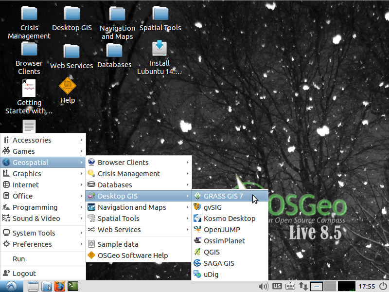
OSGeo-Live Desktop
Version 5.0 of the OSGeo-Live GIS software collection has been released.
OSGeo-Live is a self-contained bootable DVD, USB flash drive and Virtual Machine based upon Ubuntu Linux that is pre-configured with a wide variety of robust open source geospatial software.
The applications can be trialled without installing anything on your computer, simply by booting the computer from the DVD or USB drive.
A DVD or USB of OSGeo-Live is being distributed to every delegate at the upcoming international conference for Free and Open Source Software, http://2011.foss4g.org.
Homepage: http://live.osgeo.org

Highlights

  • 47 Quality GeoSpatial Open Source applications installed and pre-configured
  • Quality free world maps
  • One page overviews and quick starts for all applications
  • Overviews of key OGC standards
  • Translations for Greek, German, Polish, Spanish and Japanese

Contents

Browser Clients
  • OpenLayers 2.10 - Browser GIS Client
  • Geomajas - 1.8 Browser GIS Client
  • Mapbender 2.7.2 - Geoportal Framework
  • MapFish 2.2 - Web Mapping Framework
  • GeoMoose 2.4 - Web GIS Portal
Crisis Management
  • Sahana Eden 0.5.5 - Disaster management
  • Ushahidi 2.1 - Mapping and Timeline for events
Databases
  • PostGIS 1.5 - Spatial Database
  • SpatiaLite 2.3.1 / 2.4 beta - Lightweight Database
  • Rasdaman 8.2 - Multi-Dimensional Raster Database
  • pgRouting 1.05 - Routing for PostGIS
Desktop GIS
  • Quantum GIS (QGIS) 1.7.0
  • GRASS GIS 6.4.1
  • gvSIG Desktop 1.11
  • User-friendly Desktop Internet GIS (uDig) 1.2.2
  • Kosmo Desktop 2.0.1
  • OpenJUMP GIS 1.4.0.1
  • SAGA 2.0.7
  • OSSIM 1.8.6 - Image Processing
  • Geopublisher 1.7 - Catalogue
  • AtlasStyler 1.7 - Style Editor
  • osgEarth 2.0 - 3D Terrain Rendering
Navigation and Maps
  • GpsDrive 2.11 - GPS Navigation
  • Marble 1.0.2 - Spinning Globe
  • OpenCPN 2.5.0 - Marine GPS Chartplotter
  • OpenStreetMap Tools - JOSM, Merkaartor, Gosmore, Osmarender
  • Prune 12 - View, Edit and Convert GPS Tracks
  • Viking 9.9.94 - GPS Data Analysis and Viewer
  • zyGrib 5.0 - Weather Forecast Maps
Spatial Tools
  • GeoKettle 2.0-RC1 - ETL (Extract, Transform and Load) Tool
  • GDAL/OGR 1.8.0 - GeoSpatial Data Translation Tools
  • GMT 4.5.2 - Cartographic Rendering
  • Mapnik 0.7.1 - Cartographic Rendering
  • MapTiler 1.0beta2 - Create Map Tiles
  • OTB 3.10 - Image Processing
  • R Spatial Task View 2.12.1 - Statistical Programming
Web Services
  • GeoServer 2.1.1
  • MapServer 6.0.1
  • deegree 3.0
  • GeoNetwork 2.6.4 - Metadata Catalog and Catalog Services for Web
  • MapProxy 1.1.1 - Proxy WMS & tile services
  • QGIS Server 1.7.0 - Web Map Service
  • 52°North WSS 2.2.0 - Web Security Service
  • 52°North WPS - 2.0 RC6 - Web Processing Service
  • 52°North SOS - 3.2.0 Sensor Observation Service
  • TinyOWS 1.0 - WFS-T Service
  • ZOO Project 1.0.0 - Web Processing Service
Data
  • Natural Earth 1.3.1 - Geographic Data Sets
  • OSGeo's North Carolina, USA Educational dataset
  • OpenStreetMap - Sample extract from OpenStreetMap
Geospatial Libraries
  • GeoTools - Java GIS Toolkit
  • MetaCRS - Coordinate Reference System Transformations
  • libLAS - LiDAR Data Access

Credits

Over 80 people have directly helped with OSGeo-Live packaging, documenting and translating, and thousands have been involved in building the packaged software.
Packagers, documenters and translators include: Activity Workshop, Agustín Díez, Aikaterini Kapsampeli, Alan Boudreault, Alexandre Dube, Alex Mandel, Andrea Antonello, Andrea Yanza, Angelos Tzotsos, Anne Ghisla, Anton Patrushev, Argyros Argyridis, Astrid Emde, Brian Hamlin, Bruno Binet, Cameron Shorter, Christos Iossifidis, Dane Springmeyer, Daniel Kastl, David Terrativa, Diego González, Dominik Helle, Eike Hinderk Jürrens, Eric Lemoine, Etienne Dube, Fran Boon, François Prunayre, Frank Gasdorf, Gavin Treadgold, Gérald Fenoy, Hamish Bowman, Haruyuki Seki, Henry Addo, Hernan Olivera, Howard Butler, Ian Turton, Jackie Ng, Jan Drewnak, Javier Sanchez, Jesús Gómez, Jim Klassen, Jody Garnett, Johan Van de Wauw, Jorge Sanz, José Antonio Canalejo, Judit Mays, Klokan Petr Pridal, Kristof Lange, Lance McKee, Lars Lingner, Lucía Sanjaime, Mage Whopper, Manuel Grizonnet, Marco Puppin, Mark Leslie, Massimo Di Stefano, Mauricio Miranda, Mauricio Pazos, Michael Owonibi, Mike Adair, Milena Nowotarska, Nathaniel V. Kelso, Ned Horning, Nobusuke Iwasaki, Oliver Tonnhofer, Òscar Fonts, Otto Dassau, Pedro-Juan Ferrer, Pirmin Kalberer, Ricardo Pinho, Ruth Schoenbuchner, Samuel Mesa, Sergio Baños, Simon Cropper, Simon Pigot, Stefan A. Tzeggai, Stefan Hansen, Steve Lime, Thierry Badard, Thomas Baschetti, Trevor Wekel, Valenty Gonzalez, and Yoichi Kayama.

Sponsoring organisations:

Friday, 17 June 2011

Memoirs of a Cat Herder - Coordinating OSGeo-Live volunteers

Presented at the GeoRabble forum.
I’m about to share some insights into how to build a successful open source community.
Actually, a bit more than that - also how to tap into, and coordinate the expertise of hundreds of world leading developers, packagers, technical writers, project managers, marketers, translators and educators. And have all these people volunteer their time for free.
Because we have actually done all this - in building the OSGeo-Live project. At its core, OSGeo-Live is a DVD pre-configured with close to 50 geospatial Open Source applications, along with accompanying data and documentation, available in multiple languages. It is used in workshops and is handed out at conferences all around the world. I think I'm safe in claiming that OSGeo-Live has grown into a highly successful project, and that we have a learned a number of key lessons worth sharing.
We started OSGeo-Live in 2008 with the aim of building a DVD of geospatial open source which was to be handed out at the international conference for free and open source software for geospatial, or FOSS4G. The FOSS4G conference provides an attractive international marketing pipeline that we could offer projects. And as some of us were on the FOSS4G organising committee we were able to say, "if you get your application installed on OSGeo-Live, then we will hand this DVD out to all attendees at this highly targeted conference".
We laid out a very clear vision of our target deliverable - namely a stable release of Open Source and accompanying marketing documentation. This clear and simple goal helped us many times by providing a framework to test the multitude of decisions that are inevitably encountered in such a project.The process of building our first version of OSGeo-Live involved installing geospatial applications on a base Ubuntu distribution. We followed install instructions, configured applications, resolved dependencies and conflicts, asked questions on email lists, and finally, after much hard work, we produced our first release for the 2008 FOSS4G conference. This was a very important first step as it showed that we had the commitment to follow through and deliver.
However, it also highlighted a number of our failings. We had followed a fully manual install process, so when the next Ubuntu release came out, we had to start the installation process again, from scratch. This was completely unsustainable. We needed to automate the install process, and we needed projects to show us how.
But our first calls for help from projects was embarrassingly underwhelming. You see, the perceived learning curve for a developer to learn the intricacies of packaging was considered unacceptably high and volunteers were not stepping up.
To fix this, we got one of our packagers to write an example install script along with clear, step-by-step instructions. We then went back to developers with the message of "if you can spend a couple of hours writing a short install script which looks like this, then we will market your application on the OSGeo-Live DVD".
Small effort / High Value. And this worked! 28 projects packaged their applications for our 2.0 release.
We followed the same process with documentation, as our first round of documentation was mostly written by developers and as such was quite ... variable. So the Australian Office of Spatial Data Management stepped up and sponsored one of LISAsoft's technical writers to create a template Project Overview, along with writing instructions. We then asked projects to write the documentation, and the technical writer followed up with documentation reviews, then all the documents went through our publishing pipeline in order to produce consistent, quality material. So by applying a template / write / review / publish process, we were able to achieve significant efficiencies by allowing experts to focus only on the bits they do best and thus reduce the cost of contributing.
Another key to our success is that OSGeo-Live doesn't provide free rides for projects. If a project's community doesn't write installers and documentation, then they don't gain the marketing value of OSGeo-Live. This creates the business incentive for projects to help. It also frees up the core OSGeo-Live team to support a multitude of projects.
And by multitude, I mean 50 odd, and 70 odd volunteers, which becomes a project management challenge for a flat organisation structure like ours. To reduce swamping everyone with emails, each project nominates at a contact person to liaise between their project and OSGeo-Live. We use a wiki, issue tracker, email lists, and Google Doc spreadsheets and follow standard project management processes of managing a schedule and tracking status.
The simple statement of "if you want your application on the next release, it needs to be packaged this week" has been a motivating trigger for many of our volunteers to get started.
But the key motivator, along with the fun aspect of working on open source, is that there is a strong business case for each of our contributors to be involved.
  • Application developers get valuable marketing, and get their documentation reviewed and translated.
  • Our packagers' jobs are a lot easier because domain expects now take ownership of a large part of the packaging task.
  • By just sponsoring documentation review, The Australian government's Office of Spatial Data Management gained a 5 to 1 return on investment when creating Project Overviews
  • Translators gain quality source documentation and marketing pipeline.
  • LISAsoft, who build geospatial systems using Open Source, have increased public acceptance of Open Source, by helping coordinate OSGeo-Live.
  • For only the cost of printing, conference and workshop organisers impress delegates by giving them a free, comprehensive DVD of software.
  • Likewise, the OSGeo Foundation is gets comprehensive, translated documentation of projects which can be put on its website.
Everyone is a winner!
So if I come back to my opening statement of "what is required to tap into, and coordinate the expertise of hundreds of world leading experts, and have them volunteer their time for free?" I guess I'd say:
  • Start with a clear and compelling vision; inspiring enough that others want to adopt it and work to make it happen.
  • This should be followed by a practical and believable commitment to deliver on the vision. Typically this is demonstrated by delivering a “Minimum Viable Product”. 
  • Be in need of help, preferably accepting small modular tasks with a low barrier to entry, and ideally something which each person is uniquely qualified to provide. If anyone could fix a widget, then maybe someone else will do it. But if you are one of a few people with the skills to do the fixing, then your gift of fixing is so much more valuable, and there is a stronger moral obligation for you to step up.
  • Set a quality bar, and only accept contributions which achieve this level of quality.
  • Ensure that every participant gets more out of the project than they put in.
  • Avoid giving away free rides. If you are giving away something uniquely valuable; and it costs you time to provide that value for your volunteers; then it is okay to expect something from your volunteers if they wish to get something in return.
  • Use templates and processes to facilitate domain experts working together.
  • Reduce all barriers that may prevent people from contributing, in particular, by providing step-by-step instructions.
  • Set a schedule and work to it.
  • Talk with your community regularly, and promptly answer queries.
  • And most of all, have fun while you are doing it. Because believe you me, it is hugely rewarding to share the team camaraderie involved in building something that is much bigger and better than you could possibly create by yourself.

Monday, 28 March 2011

OSGeo-Live 4.5, the Open Source Geospatial DVD, released

Version 4.5 of the OSGeo-Live GIS software collection has been released. OSGeo-Live is a self-contained bootable DVD, USB flash drive and Virtual Machine based upon Ubuntu Linux that is pre-configured with a wide variety of robust open source geospatial software. The applications can be trialled without installing anything on your computer, simply by booting the computer from the DVD or USB drive.Highlights:
  • 45 Quality GeoSpatial Open Source applications installed and pre-configured
  • Quality free world maps
  • One page overviews and quick starts for all applications
  • Overviews of key OGC standards
  • Translations for Greek, German, Polish, Spanish and Japanese
Packages:
  • 52º North SOS (Sensor Observation Service) 3.1.1
  • 52º North WPS (Web Processing Service) 2.0 RC6
  • AtlasStyler (Feature Style Editor) 1.6
  • deegree (Web Services) 2.3
  • GDAL/OGR (GeoSpatial Data Translation Tools) 1.7.3
  • GeoKettle (Business Intelligence) 3.2.0-20090609
  • Geomajas (Browser GIS Client) 1.8
  • GeoNetwork (Metadata Catalog) 2.6.3
  • Geopublisher (Electronic Library Manager) 1.6
  • GeoServer (Web Service) 2.1rc1
  • GMT (Generic Mapping Tools) 4.5.1
  • GpsDrive (GPS Navigation Software) 2.11
  • GRASS GIS (Fully featured GIS) 6.4.0
  • gvSIG Desktop (Desktop GIS) 1.10
  • Kosmo Desktop (Desktop GIS) 2.0
  • Mapbender (Geoportal Framework) 2.7
  • MapFish (Web Mapping Framework) 2.0
  • MapGuide Open Source (Web Service) 2.2.0
  • Mapnik (Cartographic rendering engine) 0.7.0
  • MapServer (Web Service) 5.6.6
  • MapTiler (Tiled Map Publishing) 1.0beta2
  • Marble (3D desktop globe) 0.9.5
  • MB-System (Sea floor mapping) 5.2.1880
  • OpenCPN (Marine GPS navigation) 2.3.1
  • OpenJUMP GIS (Desktop GIS) 1.4.0.1
  • OpenLayers (Browser GIS Client) 2.10
  • osgEarth (Terrain rendering toolkit) 2.0
  • OpenStreetMap (Tools for mapping the world) 3751
  • OSSIM (Image Processing) 1.8.10
  • OTB - ORFEO Toolbox Library (Image Processing) 3.8.0
  • pgRouting (GIS Tools) 1.05
  • PostGIS (Spatial Database) 1.5.2
  • Prune (GPS Track Editing) 10-1 Lucid
  • Quantum GIS (Desktop GIS) 1.6.0
  • QGIS mapserver (Web Service) 1.6.0
  • Rasdaman (Multi-Dimensional Raster Database) 8.1
  • R Spatial (Statistical Programming) 2.12.1
  • SAGA (Desktop GIS) 2.0.5
  • Sahana (Disaster management) Eden 0.5.3
  • SpatiaLite (Spatial Database) 2.4
  • uDig (Desktop GIS) 1.2.0
  • Ushahidi (Crowd Sourced Event Mapping) 2.0.1
  • Viking (Manage and plot GPS data) 0.9.9
  • ZOO Project (Web Processing Service) 1.2.0
  • zyGrib (Weather forecasting) 3.9.9.1

Credits:

Over 60 people have directly helped with OSGeo-Live packaging, documenting and translating, and thousands have been involved in building the packaged software.

Packagers and documenters: Alan Boudreault, Alex Mandel, Alexandre Dube, Andrea Antonello, Anton Patrushev, Astrid Emde, Brian Hamlin, Bruno Binet, Cameron Shorter, Dane Springmeyer, Daniel Kastl, Eike Hinderk Jürrens, Eric Lemoine, Etienne Dube, Fran Boon, François Prunayre, Gavin Treadgold, Gérald Fenoy, Hamish Bowman, Haruyuki Seki, Henry Addo, Ian Turton, Jody Garnett, Johan Van de Wauw, Jorge Sanz, Juan Lucas Domínguez Rubio, Judit Mays, Klokan Petr Pridal, Kristof Lange, Lance McKee, Manuel Grizonnet, Mark Leslie, Massimo Di Stefano, Michael Owonibi, Nathaniel V. Kelso, Pirmin Kalberer, Ricardo Pinho, Sergio Baños, Simon Pigot, Stefan A. Tzeggai, Stefan Hansen, Thierry Badard and Trevor Wekel

Translators: Aikaterini Kapsampeli, Angelos Tzotsos, Anne Ghisla, Argyros Argyridis, Astrid Emde, Christos Iossifidis, Daniel Kastl, Haruyuki Seki, Javier Sanchez, Jorge Sanz, Lars Lingner, Marco Puppin, Massimo Di Stefano, Milena Nowotaska, Nobusuke Iwasaki, Otto Dassau, Ruth Schoenbuchner, Thomas Baschetti, Valenty Gonzalez and Yoichi Kayama

Sponsoring institutions:

LISAsoft provides sustaining resources and staff toward the management and packaging of software onto the Live DVD. http://www.lisasoft.com

Information Center for the Environment at the University of California, Davis provides hardware resources and development support to the OSGeo Live project. http://ice.ucdavis.edu

The DebianGIS and UbuntuGIS teams provide and quality-assure many of the core packages.

The Australian Government's Office of Spatial Data Management sponsored reviews of software marketing documentation. http://www.osdm.gov.au

Friday, 3 September 2010

Video of the best GeoSpatial Open Source - OSGeo-Live


Version 4.0 of the OSGeo Live GIS software collection has been released, along with a "teaser" 25 minute video describing the 42 contributing GeoSpatial Open Source applications.

Jody Garnett will be providing a much better, more detailed, 90 minute presentation at the start of FOSS4G next week. Don't miss it!

OSGeo-Live is a self-contained bootable DVD, USB flash drive and Virtual Machine based upon Ubuntu Linux that is pre-configured with a wide variety of robust open source geospatial software. The applications can be trialled without installing anything on your computer, simply by booting the computer from the DVD or USB drive.

Homepage
http://live.osgeo.org
Video
http://cameronshorter.blip.tv/file/4078371/

Highlights

  • 42 of the best GeoSpatial Open Source applications installed and pre-configured.
  • One page overviews for all projects
  • Overviews of key OGC standards
  • Many application Quick Start documentation

Packages

  • 52°North WPS 2.0.0
  • AtlasStyler 1.5
  • deegree 2.3
  • GeoKettle 3.2.0-20090609
  • Geomajas 1.6.0
  • GeoNetwork 2.4.3
  • Geopublisher 1.5
  • GeoServer 2.0.2
  • GMT 4.5.1
  • GpsDrive 2.11
  • GRASS GIS 6.4.0rc6
  • gvSIG 1.10
  • Kosmo 2.0
  • Mapbender 2.6.2
  • Mapfish 1.2
  • MapGuide Open Source 2.2.0
  • Mapnik 0.7.0
  • Mapserver 5.6.5
  • MapTiler 1.0beta2
  • Marble 0.9.2
  • MB System 5.1.2
  • OpenJUMP 1.3
  • OpenLayers 2.9.1
  • OpenCPN 2.1.0
  • OpenStreetMap editors and tools
  • osgEarth 1.3
  • Ossim/OssimPlanet 1.8.6
  • pgRouting 1.03svn
  • PostGIS 1.5
  • QuantumGIS 1.5.0
  • QGIS mapserver 0.7
  • R geostatistics 2.11.1
  • Sahana 0.6.4
  • SAGA GIS 2.0.4
  • SpatiaLite 2.4
  • Tilecache
  • uDig 1.2.0
  • Ushahidi 1.1.0
  • Viking 0.9.9
  • zyGrib 3.9.2
  • ZOO Project 1.0
  • Xubuntu 10.04 (Lucid)

Tuesday, 27 July 2010

OGC and OSGeo collaborate on documentation


The Open Geospatial Consortium, Inc. (OGC®) and the Open Source Geospatial Foundation (OSGeo) will develop conforming documentation for key OGC standards and geospatial open source application descriptions. Both sets of documentation will be available online and on the OSGeo-Live DVD, to be released at the international conference for Free and Open Source Software, FOSS4G, in September 2010, in Barcelona, Spain (http://2010.foss4g.org).
“We are happy to work with OSGeo to meet the needs of open source developers,” explained Steven Ramage, Executive Director, Marketing and Communications, OGC, “because wider use of OGC standards increases interoperability, innovation and market growth, and this benefits developers and users of both open source and proprietary software.”
According to Cameron Shorter, coordinator of the OSGeo-Live project,
“OGC standards underpin our GeoSpatial Open Source applications, and hence OGC documentation will greatly enhance the Open Source documentation being developed.”

About OSGeo-Live

OSGeo-Live is a DVD, USB drive and Virtual Machine based upon Ubuntu Linux that is pre-configured with a wide variety of robust, open source, geospatial software. The applications can be trialed without installing anything on your computer, simply by booting the computer from the DVD or USB drive. OSGeo Live is handed out at conferences around the world, and is regularly used by students in geospatial workshops and tutorials. (http://live.osgeo.org)

About OSGeo
The Open Source Geospatial Foundation, or OSGeo is a not-for-profit organization whose mission is to support and promote the collaborative development of open geospatial technologies and data. (http://www.osgeo.org/)

About the Open Geospatial Consortium (OGC®)
The OGC® is an international consortium of more than 395 companies, government agencies, research organizations, and universities participating in a consensus process to develop publicly available geospatial standards. OGC Standards empower technology developers to make geospatial information and services accessible and useful with any application that needs to be geospatially enabled. Visit the OGC website at http://www.opengeospatial.org/contact.

Monday, 28 June 2010

One week till OSGeo-Live Feature Freeze

In one week, we will be locking in software versions on this year's OSGeo-Live DVD, which will be handed to every delegate at FOSS4G 2010, as well as many other Geospatial events. At the OSGeo stand at conferences, the OSGeo-Live DVD is by far the most sought after marketing item we have, with delegates consistently asking for extra copies.

So please ensure that all install scripts are pointing at the latest stable software, and if you wish to see your favorite stable OSGeo application on OSGeo-Live, then contact us right now.

Resources

About OSGeo-Live

OSGeo-live is an XUbuntu based distribution of Geospatial Open Source Software, available via a Live DVD, Virtual Machine and soon to be released USB. You can use OSGeo-Live to try a wide variety of open source geospatial software without installing anything.

Saturday, 12 June 2010

Building OSGeo Live DVD for FOSS4G 2010

We have started building this year's OSGeo-Live DVD which will be handed out to every delegate at FOSS4G 2010, as well as many other Geospatial events.

This year, OSGeo-Live will be even sexier, more useful and professional by including:

We want to hear from:

  • Established GeoSpatial projects who wish to include their project in OSGeo-Live
  • Workshop leaders or trainers who wish to use OSGeo-Live. We'd like to know how we can help you.
  • Project representatives please:

Milestones

  • 25 July 2010: Documentation template ready for use
  • 5 July 2010: Feature freeze
  • 2 August 2010: Final delivery for User Acceptance Test

..more

About OSGeo-Live

OSGeo-live is an XUbuntu based distribution of Geospatial Open Source Software, available via a Live DVD, Virtual Machine and soon to be released USB. You can use OSGeo-Live to try a wide variety of open source geospatial software without installing anything.

Contact Us?

Website: http://live.osgeo.org

Mailing List: http://lists.osgeo.org/mailman/listinfo/live-demo

or contact Cameron Shorter directly at: cameronD O TshorterATlisasoftD O Tcom.

Monday, 29 March 2010

OSGeo Live DVD and Virtual Machine released

The Geospatial LiveDVD team is pleased to announce version 3.0 of the OSGeo GeoSpatial Live DVD and Virtual Machine, code named Arramagong.

From the Arramagong LiveDVD, you can try the best of GeoSpatial Open Source Software(OSS) without installing any applications on your computer. As a royalty free, reference release with fully tested and configured OSS stack, the LiveDVD is ideal for training, demonstration and public outreach.

The LiveDVD is based on XUbuntu 9.10 so it can be run on most computers simply by rebooting the computer with the DVD inserted. The Arramagong LiveDVD also comes with Windows and Macintosh installers for many of the GeoSpatial applications too.

Highlights from this 3.0 release include:

  • 34 of the best GeoSpatial Open Source applications included.
  • 14 new applications added since release 2.0, at FOSS4G 2009
  • 13 applications updated
  • Formalised testing introduced for all packages as part of the release process
  • Plus lots of general improvements and fixes

Downloads:

http://download.osgeo.org/livedvd

Packages:

  • AtlasStyler SLD editor and Geopublisher :: 1.4 (new)
  • deegree WMS, WFS, WCS and iGeoPortal :: 2.2
  • GDAL :: 1.6.3
  • GeoKettle :: 3.2.0-20090609
  • Geomajas :: 1.4.2 (new)
  • GeoNetwork :: 2.4.2
  • GeoServer :: 2.0.1
  • GMT: The Generic Mapping tools :: 4.4.0 (new)
  • GpsDrive :: 2.10pre7
  • GRASS GIS :: 6.4.0rc5
  • gvSIG :: 1.9 stable
  • Kosmo :: 2.0 RC1
  • Mapfish :: 1.2 (new)
  • Mapnik :: 0.6.1 (new)
  • Mapserver :: 5.6.1
  • MapTiler :: 1.0 beta2
  • Marble :: 0.8.1
  • MB System :: 5.1.2
  • Octave Mapping Toolbox :: 3.0 / 1.0.7 (new)
  • Open Jump :: 1.3
  • Open Layers :: 2.8 (new)
  • OpenCPN :: 1.3.6 (new)
  • OpenStreetMap editors and tools :: JOSM svn1788, Gosmore svn20090624 (new)
  • osgEarth :: 1.3 (new)
  • Ossim/OssimPlanet :: 1.8.3 (new)
  • pgRouting :: 1.04
  • Postgres/PostGIS :: 8.4/1.4
  • PROJ.4 :: 4.7.0 (new)
  • QuantumGIS :: 1.4.0
  • R geostatistics :: 2.10.1
  • SpatiaLite :: 2.4.0 (new)
  • uDig :: 1.2RC1
  • Unofficial gvSIG Mobile for Linux :: 0.1.6 (new)
  • Xubuntu :: 9.10

Interested?

You can find more details about the project on our wiki at: http://wiki.osgeo.org/wiki/Live_GIS_Disc

Us packagers are keen to help projects make use of the next release of the Live DVD at this year's OSGeo FOSS4G conference, http://2010.foss4g.org. Can you use the Live DVD in your presentations, tutorials or workshops? Talk to us about it.

Friday, 5 March 2010

Does your favourite OSGeo application work on the LiveDVD?

This weekend, we will be cutting our last release candidate of the 3.0 LiveDVD which is targeted to be handed out at at number of spatial conferences in the April->July 2010 time period.
The DVD is looking really good, we have updated a number of packages, as well as improvement the look and feel.
Our only problem is that us packagers don't have the expertise to verify that each of the applications have been installed and runs correctly, and we are asking for help to document 10 to 20 test steps for each package.
Could we please get some help filling in test steps for each project here:
http://wiki.osgeo.org/wiki/Live_GIS_Disc_Testing
We would like people to use the template format here:
http://wiki.osgeo.org/wiki/Live_GIS_Disc_Testing#template
Deegree has filled out an excellent set of steps as an example here:
http://wiki.osgeo.org/wiki/Live_GIS_Disc_Testing#deegree
We will take any test steps that people can provide us. Feel free to update existing steps, as we are aware that some are based against old versions of the DVD and don't follow the template.
If you have downloaded the one of the 3.0 DVDs, as per: http://download.osgeo.org , then please write test steps from there.
Alternatively, you can write against the click2try 2.0 browser based viewer of the Virtual Machine, as explained here:
http://wiki.osgeo.org/wiki/Live_GIS_Disc#Click2Try:_run_from_browser
Alternatively, use a default install of the software you have on your computer, which should be similar to the LiveDVD install.
Lastly, thanks in advance for your help. Providing these testing steps helps us provide a quality DVD we can all be proud to hand out at conferences.

Saturday, 27 February 2010

FOSS4G Registration Metrics


With excitement building around the 2010 conference for Free and Open Source Software for GeoSpatial, http://2010.foss4g.org, I think it is timely to share registration metrics from previous conferences (from 2006 to 2009).

Some key highlights from the metrics are:
  • FOSS4G traditionally attracts ~ 50% of its delegates from the locally hosted country, and up to 75% of its delegates from the local region. This highlights the value of moving the FOSS4G conference around the world as it boosts exposure to local communities. This metric also helps predict attendance numbers based on region population densities. Small nations in the middle of the Ocean, like Australia have less delegates to draw upon, but we should see big attendance numbers coming into Barcelona this year.
  • Over 80% of people heard about the conference virally, via a friend, email list, blog, etc. Despite us having contra-deals and advertisements with many geospatial magazines, only 1% heard about the conference through a magazine. Lesson for organisors: focus on viral marketing.
  • 3/4 of the delegates are technical.
  • Half the local registrations come in late, after the early bird registration. In Barcelona with expected high numbers, it might mean that the conference organisors will need to turn away late registrations.
I'd love to see some of these metrics built into map displays. If you are a mapping wizard, you might want to create some fancy maps with these figures. Please let me know if you do, and I'll reference them from this blog.

Saturday, 19 December 2009

Will there be an OSGeo Desktop shootout at FOSS4G 2010?

Delegates who voted for the FOSS4G 2009 presentations ranked the OSGeo comparison projects very highly, which is something I suggest hopeful FOSS4G 2010 presenters take note of, because competition for speaking slots will be fierce.

At FOSS4G 2009, 183 quality presentations were submitted, and there was only 85 speaking slots. In 2010 it is likely to be much harder, as there is expected to be 2 to 3 times more delegates and many more hopeful presenters.

In 2009 the community ranked potential presentations, and some of the highest ranked presentations targeted the comparison of popular packages. Unfortunately, there were only a few of these types of presentations.

The presentations were:
  • Ranked 2: The WMS Performance Shootout
  • Ranked 8: PostGIS and Oracle Spatial
  • Ranked 9: There is no alternative to Openlayers...? (discussing OpenLayers vs other AJAX clients)
The moral to the story is that delegates want to see how different projects compare, and to date we have had a shortage of such presentations (partly because they are a lot of work to set up).

However, I strongly suggest that projects start teaming together to put together such presentations for 2010.

In particular, I'd love to see comparisons between:
  • Geospatial Desktop applications
  • Geospatial Browser based applications
  • Geospatial Servers (WMS, WFS, Tiled Services at the very least)
The comparisons could cover some or all of:
  • performance
  • robustness
  • features
  • ease of setup or use
The tests should not be restricted to Open Source, but be open to proprietary vendors too. (ESRI and ERDAS were invited to participate in the 2009 WMS shootout, and it seems likely they will participate in 2010).

So who wants to participate?

Thursday, 17 December 2009

Planning for next year's GIS Live DVD


We are planning two Arramagong GIS Live DVD releases during 2010 and would like to know what applications and functionality people would like to contribute.

Arramagong is based on XUbuntu and GISVM, and allows you to try a wide variety of open source geospatial software without installing anything. It is currently available as:

The core success of the Arramagong LiveDVD is due to the simple yet powerful build scripts. All that is required for a relevant project to be incorporated into the LiveDVD is to write a bash shell script which installs the application onto an Ubuntu distribution. Hence, our last distribution attracted over 20 developers and from project announcement to a released distribution took under 6 weeks.

The stack of popular GeoSpatial Open Source Applications included on the Arramagong LiveDVD includes:

  • deegree
  • GDAL
  • GeoKettle
  • GeoNetwork
  • GeoServer
  • GpsDrive
  • GRASS
  • gvSIG
  • Kosmo
  • Mapfish
  • Mapnik
  • Mapserver
  • MapTiler
  • Marble
  • MB System
  • Open Jump
  • Open Layers
  • pgRouting
  • PostGIS
  • PROJ.4
  • QuantumGIS
  • uDig

Milestones

  • 24 Jan 2010: Version 3.0 Feature Freeze
  • 07 Mar 2010: Version 3.0 Final Release
  • 05 Jul 2010: Version 4.0 Feature Freeze
  • 16 Aug 2010: Version 4.0 Final Release (ready for FOSS4G 2010)

Ideas for future releases

  • Upgrade to Xubuntu 9.10

Should there be sufficient interest, we would like to address the following:

  • Upgrade packages to latest versions
  • Incorporate new Geospatial packages
  • General cleanup
  • Incorporate help, tutorials, and training material
  • Apply internationalisation

Interested?

You can find more details about the project on our wiki at: http://wiki.osgeo.org/wiki/Live_GIS_Disc

Then please contact our mailing list at: http://lists.osgeo.org/mailman/listinfo/live-demo or contact Cameron Shorter directly at: cameronD O TshorterATlisasoftD O Tcom.

Friday, 16 October 2009

Try Open Source Geospatial desktop applications from a web browser

Sydney, Australia. 16 October 2009. http://2009.foss4g.org

The Arramagong/GISVM GeoSpatial Live DVD and Virtual Machine, which includes a stack of popular GeoSpatial Open Source Applications and is being handed out to delegates at the FOSS4G conference, can now be viewed from http://click2try.com from within your web browser!

All you need to do is:

  1. Click the big Try this application now button.
  2. Review the connection test results and fix, if necessary.
  3. Either wait for the application to launch or click the Launch App button.
  • Login to the Arramagong desktop using the login credentials in the Quick Start guide in the left pane of the window.
  • You should see the icons for the Geospatial applications on the desktop. You can start and try any application.
  • To save data, you'll need to apply for a free click2try account at http://www.click2try.com/component/user/?task=register.

About Arramagong

Arramagong is a self-contained live DVD and Virtual Machine, based on XUbuntu and GISVM, that allows you to try a wide variety of open source geospatial software without installing anything. It is composed entirely of free software, allowing it to be freely distributed, duplicated and passed around. A full list of installed packages is at: http://www.arramagong.com/Arramagong/contents.html

As explained by Cameron Shorter, coordinator of Arramagong and Geospatial Solutions Manager at LISAsoft,

"Arramagong allows users to easily try out the robust, feature rich stack of applications offered by Geospatial Open Source. It is a compelling marketing tool for us organisations who support Open Source."

About FOSS4G

http://2009.foss4g.org

FOSS4G is the international Free and Open Source Software for Geospatial conference, which comes to Sydney, Australia, 20-23 October 2009. FOSS4G offers presentations, workshops, demos, an install-fest, and a code sprint. It is presented by the world's best Developers, Policy Makers, Sponsors and Geospatial Professionals and includes the latest geospatial applications, standards, government programs, business processes and case studies. Topics include mobile platforms, location based applications, crowd sourcing, cloud computing, development, spatial standards, integration of cross-agency data, Spatial Data Infrastructures, Sensor Webs, Web Processing Services, Integration of Open Source and Proprietary Software and more.

About Click2Try

http://click2try.com/

click2try is an online Open Source application showroom that helps visitors easily evaluate and use Open Source Software from within their web browser. click2try employs a unique, advanced technology framework, built completely on Open Source software, to provide on-demand, multiuser, concurrent access to enterprise-level Open Source software applications.

Upcoming milestones

  • 20 Oct 2009, FOSS4G Workshop
  • 21-23 Oct 2009, FOSS4G Presentations and Tutorials
  • 24 Oct 2009, FOSS4G Code Sprint

Media Sponsors